Saturday, December 11, 2010

Orange Bubble Express

Today we celebrated our first day back at "The Canyons", our preferred local ski resort where we graciously partook of the worlds finest powder. They delayed their opening this year due to some major renovations (to the tune of $40 mil). We normally kick off the season on thanksgiving but had to wait an extra 2 weeks. (We actually snuck a day at snowbird because we couldn't wait any longer :)) They just installed North America's first heated bubble chairlift so we of course had to check it out. It's like riding in a giant pair of orange ski goggles and delivers you a good 2/3 of the way up the entire resort. Looking forward to yet another epic season skiing with the family.


Willster preparing to shred some serious "pow"


My Jo bug getting ready to ski "pin ball alley", his first black diamond


Looking back towards our favorite town!

Tuesday, November 30, 2010

The Violinists Backed Out

I have always loved Christmas music since I was a kid. I was enthralled with Manheim Steamroller Christmas music when I was a kid. I even made up my own arrangement of "Silent Night" that I played by ear based on their version. I think I've since learned about 5 different versions of Silent Night. I learned this arrangement by James Koerts for our church program over the weekend because the violinists backed out at the last minute. It has quickly become one of my favorite Christmas song books.

Tuesday, November 16, 2010

Spry Canyon


Today was the first ever canyoneering experience where I lost track of the number of rappels in a single canyon. Spry canyon is famous for this. The morning began with a brisk walk up the upper section of pine creek to the spry canyon pass. It was a bit challenging with the soreness from the misery canyon hike a day earlier. Today we were carrying a much thicker rope as well and so the added weight wasn't welcome.


Here's a shot of spry pass looking across Zion at the west temple.


As the canyon rapidly narrowed, we were greeted by our first rappel of the day measuring 165 feet. We threw on the wetsuits and made our way down.


This was my favorite of the day. A nice 70 footer into a very dark chasm. It was right out of an episode of discovery channels "planet earth".


The day wouldn't be complete without some november bone chilling water. I honestly don't even remember which rappel this was but the water greeted us at stage two of the 100 footer.


John B descending. (notice the rope bag below)


We were finally able to take off our wetsuits and get dry clothes on before this 100 foot dramatic finish to a great day.


The evening hike out to mt. Carmel highway was magical and the Thai food in town was equally as good.

Monday, November 15, 2010

Misery Canyon

Given the title of my post I'm sure you are thinking something bad happened to me on a canyoneering adventure. As it turns out this is the name of the deep slot canyon we explored today just outside the boundary of Zion national park. The only miserable part of the day was the hike out from the river bottom of the magical Parunawheap canyon.


With a wetsuit and neoprene socks the water was much warmer than you would expect this time of year.


My fellow adventure seeker father in law "on rappel".


The end of "west fork misery canyon" meets the parunawheap river which is essentially the east fork of the virgin river. The better known Zion narrows are considered the north fork of the virgin. The scenery down here easily rivals the famous Zion narrows. The park service no longer permits people to hike this canyon inside the park boundary. This photo shot is still outside the park boundary. Our miserable steep 1400 ft hike out was just around the corner.

Monday, October 25, 2010

Piano Fish

When I was a kid I had a cool fish tank in my bedroom that was my pride and joy. Like most kids, I really hated practicing the piano. My mom created an incentive system where she would buy me 1 fish for my tank for every 7 hours of practicing I did. I thought it was a great system. Too bad that system is no longer in place for my adult years. She would owe me an entire pet store by now.

Here's a great song titled "Run Away With Me" I posted a couple of days ago that someone posted a response to. Written by a lesser known couple Kait Kerrigan and Brian Lowdermilk they are taking New York by storm with their "new" musicals. They recently wrote a musical based on the children's book series "Henry and Mudge". My wife and kids have read the entire series many times.

Tuesday, September 28, 2010

Business Trip

Sometimes you have to make the most out of your boring lonely evenings when traveling on business. It just so happens that my business travels have brought me to Moab for a couple of days to implement a system for the State of Utah at Dead Horse State Park. I haven't been to that place since I was last there with my friend GRC many years ago. My only memory is GRC wrapping his video camera in a pillow then fastening a rope and throwing it over the edge of the cliff while the camera was rolling. He can tell the rest.

I've been to Moab a million times in my life and never really ventured into the La Sal mountains to the east. This range is huge (and very tall) and is perhaps the most prominent landmark on the Colorado plateau. With the autumn leaves rapidly changing, the mountains were a red cape and I was a bull. The roads are rough but who cares when you have a rental car :) I actually started up La Sal pass road but chickened out when it got too steep. I then headed for Geyser pass road, drove up to Burro pass trailhead and then took the little spur road to the appropriately named "Gold Basin" which was definitely the highlight. (I used my SPOT satellite tracker which you can see at the bottom of this page).


The rental car and Mt. Tomasaki (12096 ft) in the background


The burro pass trail and Manns Peak (12152 ft) in the background


Gold Basin with Mt Mellenthin (12592 ft) peering it's head


Too bad the iPhone doesn't do justice, but you get the idea


I've driven the Alpine Loop in autumn many times, but due to size, quantity and the fact that I saw a total of 4 other people the entire evening makes this a new favorite. Pretty shocking considering Disney Euro Moab is only a 30 minute drive away.

Wednesday, September 8, 2010

I Wish I Could Go Back To College

Here's a song from Avenue Q which I learned a few months back. I never thought anyone would find any use for it but I guess these guys did. I learned it from the actual score (which I prefer). The arrangements are usually more interesting to play. If only I could just go back to college..ha ha....

Wednesday, September 1, 2010

I've Been

This is the 1st song I ever heard from the Next To Normal soundtrack. I was instantly hooked on the music of Tom Kitt. Of all the piano tracks I've posted, this one has been used the most on youtube by vocalists. I'm pretty sure this guy will play the role someday with this voice. He obviously has great taste in broadway music. (notice the Sweeney Todd poster in the background).

Wednesday, August 4, 2010

He's Not Here

Music for me has become a highly addictive drug. It's hard to explain. I drive down the road listening to Pandora on my iPhone constantly thinking, I wonder what that would sound like on the piano? The number of "my favorite" videos on my youtube channel is getting close to the number of videos I have uploaded. I've decided to feature youtube responses that I really like on my adventure log. (I actually really like them all but find some extremely high quality). Here's another great tune from Next To Normal.

Thursday, July 15, 2010

Youtube Video Response

I guess you could call piano playing an adventure of sorts, but probably not exactly as epic as motorcycle riding through rugged Utah! As you might already know, I've been uploading various vocal arrangements and songs I've learned on the piano these past few months. It's quite interesting how many people from around the world have found them and used them in various ways. One individual emailed not too long ago requesting use of my "Louder Than Words" arrangement for a vocal concert. She said her accompanist kept "messing it up".

The embedded video on my blog was recently uploaded that I found particularly interesting. Using recording technology and my piano track, this girl was able to record all the different parts of the song and harmonize. It is from a new musical titled "Next To Normal" by Tom Kitt and Brian Yorkey. It's a "rock" style musical very similar to RENT which I also have a great love for.


I list all youtube video responses to my recordings in "my favorites" on my youtube channel. Check them out if you have spare time to kill.

http://www.youtube.com/user/spyderjosh#p/f

I guess this is my version of watching American Idol since I have actually never watched an entire episode of Idol in my life!

(just a disclaimer, this show has some songs which aren't appropriate for little kids so make sure you don't run out and buy the CD and fire it up in the car on your way to swimming lessons: Most of the songs are just fine however)

Tuesday, June 29, 2010

Utah Moto Day 6

I slept peacefully at the lovely "Village Inn Motel" of Castledale Utah knowing that Cody was not rotting in the grey desert of Green River. The normal noise of a busy hotel morning was non-existant only because we were the only guests that night. The owner told us to go ahead and park our bikes on the sidewalk in front of our rooms. We even considered just pulling them into the room and parking them in front of the beds for a little added security. As you can see from the photo, the lodging business is of course thriving in Castledale.


I loaded my bike after repairing my chain guard from the jacket eating incident and we were off to find a nice cafe for breakfast. Imagine that, another bike repair.


After cruising the main drag of Castledale, it was either a harsh Maverik breakfast or a 10 mile ride north to the much bigger town of Hunington. Arriving in Hunington, it was obvious that we were faced with a similar problem. So I stopped at the local Sinclair and asked the attendant on duty where a good breakfast might be found. He said, head back south to "Cindy's Cafe" which he claimed is a local favorite for homestyle cooking. Upon arriving at Cindy's, it was deserted and a sign was hung on the door with the words "Closed due to Circumstances". I was really starting to feel for the people of Carbon County. So breakfast it was at the local Subway inside the gas station. Not exactly what we had in mind, but it was stomach fuel nonetheless.


We gassed the bikes for the final time of the journey and started up SR31 which heads west from Castledale to Fairview Canyon. We immediately started to climb as the forest grew thicker. We passed many coal mines along the highway and I kept my eyes peeled for any sign of the famous Crandall Canyon mine where 9 people were killed a few years back but I think it might be a few canyons over.

Once we hit the top of the mountain pass, it was time to make our way north on the famous Utah Skyline trail. During our last adventure, we came south on this recreational dirt highway so this was familiar territory for us. If you ever get the chance, you should take the family car up fairview canyon and drive atleast a couple miles of this finely graded gravel road. You can see more Utah mountain ranges from the elevation than anywhere in Utah in my opinion. In the photo you can see the backside of Mt. Nebo which you pass when you drive through Nephi.


The purple wildflowers along the skyline trail were outstanding and covered the lush green meadows and fields of the 10,000 foot skyline. We stopped multiple times to capture the beauty.


As we started to descend the skyline approaching US6, we encountered a huge herd of sheep on the road. I thought for sure they would scramble as we approached. After a few "revs" of the throttle, I think they thought I was firing up a chainsaw in preparation for sacrifice so they immediately scrambled.


We met up with US6 and rode a few miles west to the sheep creek dirt road which takes you over the mountains to Strawberry reservoir. Again, this road was the on-ramp to our previous journey a few years back so it was extremely familiar territory. It makes for an excellent, more scenic and safer shortcut to US6 than driving the wasatch front where you might get killed by a cell phone talking minivan on I-15.

As we finally reach US40 and the entrance to Strawberry reservoir, it was time to pull out the license plate out of my pant pockets and use my MacGyver techniques to re-attach it to my bike. I think I failed to mention that I it was destroyed a few days back in Beef Basin while riding out of the Abajos. The extreme weight from my gear caused my rear to bottom out and make contact with the tire. If you don't find enjoyment in fixing your bike everyday, you might want to stick with a conventional hobby such as tennis. Notice the long strip of duct tape attached to my saddle bag.


From there it was maybe 1 hour to home. It was a great journey but in a lot of ways, it was nice to be home as well. Since my expert wife photographer wasn't home to snap our photo, we parked the bikes in front of the garage, placed the cameras on the garbage can and set the timers.


We were standing in the kitchen having a nice cold drink when Allison and kids arrived home. They walked in the house and the first words out of Jonas' mouth was "where is Cody Maverik?". I almost teared up thinking how much worst and dramatic this moment could have been and proudly took him in the garage where Cody was still securely strapped to the handlebars. I said, let's take a photo with you and your stuffed animals by the bikes. Jonas already had his most beloved dog "buddy" with him so he allowed Will to hold Cody. Sasha wasn't about to be left out and ran in the house to grab her favorite doll "baby".


I'm sure there will be many more journeys. Considering how much of Utah we've covered now, we may have to start heading west into Nevada, North into Idaho, or East into Colorado. The list of bike repairs, modifications and tweaks is huge and should give us something to do in late hours of the night when the kids are in bed. It's always nice to have something to look forward to.

Total miles today: 167

Total Miles for the entire trip: 1098 (1200 for Van. He had to ride from Kaysville)

We figure atleast 75% of the route was dirt road and trails and of course the grey Green River desert. As you can see, we've made some tracks on the Utah map. There are still a few mountain ranges I've yet to cross in our great state but plan to at some point. Here's a map showing our 2008 and 2010 rides combined. 2008 in Yellow and 2010 in Black.

Monday, June 28, 2010

Utah Moto Day 5

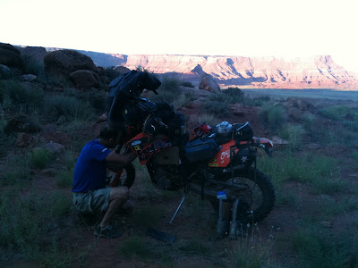
The silence of Lockhart basin was almost spooky. It was the quietest place I had ever spent the night. It reminded me a lot of Lake Powell without the water splashing and sloshing during the night. The moon was full and radiated through my tent light a giant fluorescent light. I slept like an absolute rock after the motorcycle eco-challenge through the Needles. As morning broke, the sun had not yet hit our camp. We decided to get things packed before the heat hit us. I had to re-attach both radiators on my bike which got knocked loose the previous day from the moto-mayhem on Elephant hill. This is why you carry tools. I carry a tool for every single nut and bolt that exists on my bike. You just never know and Lockhart would not be a place to be missing a desperately needed tool.


We still had a good 45 or so miles of brutal rocky jeep trail before reaching Moab. It was definitely slow going but as the trail twisted and turned with the contour of the geography, we would constantly go from sunshine to shade. Occasionally we would hit some climbs which would require me to stop and give it a good look before making the final path selection. Overall the ride was pleasant but slow going to the tune of 15 - 20 mph. This drive would take days in a jeep.

Eventually we came to a fairly steep descent down into the main plateau just before heading up to Hurrah Pass. All of the sudden we passed a group of people riding ATVs with no helmet of course headed out to Chicken Corners overlook on the Colorado. The no helmet thing is quite common with ATV riders.

Hurrah pass felt like a major milestone but we still had a good 15 to 20 miles into Moab. Once we reached Moab, it was time to head to the Pancake Haus which serves up some serious breakfast for the hungry "Moab-ite".

As we were getting seated, there was a guy standing there with his full moto gear and KTM riding jacket. Of course we looked at each other and realized we were from the same tribe and decided to all have breakfast together. Turns out this guy is riding his KTM across the "TAT" or Transamerican Trail which is a special route designed for street-legal dirtbikes. The full ride distance is 4800 miles coast to coast and he was about 2500 miles into it at Moab.

After breakfast, we of course had to go outside and check out his bike fully loaded with every gadget imaginable. He is riding the KTM adventure 640 which is a much heavier bike. His chance of riding that thing up Elephant hill would have been slim to nothing. It would have required a helicopter airlift to get that thing out of the Needles.


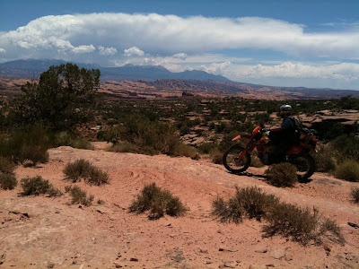
We gassed the bikes up at the local Maverik and poured a gallon of ice cold water over our heads and started out towards the Gemini Bridges trailhead to start making our way north-west towards Green River. Here is a picture looking back towards Moab over Poison Spider Mesa and the La Sal Mountain range. The scenery in this part of Utah never disappoints.


We hit pavement on the Canyonlands Dead Horse state park highway and then started west on another dirt road. The original route I had planned was supposed to take us over the Crystal Geyser jeep trail but for some reason took us to a dead end where an old oil pump was slowly sucking crude out of the earth. We back tracked a bit and found a road heading due west. I thought for sure this would take us to Green River. Turns out the road we were on was the "Secret Spire" trail which ultimately took us to the canyon bottom and along the banks of the Green River. The topo map I was carrying in my pack showed the road going north for a while and then a little squigly line exiting out the canyon to the top. We rode for about 5 miles and then decided there was no way we were going to get our bikes out via a little black squigly line on the map. So we turned around and eventually made our way to Green River. This is a photo of the switchback loaded road going under the "Secret Spire" into the canyon bottom.


Our little detour to the "Secret Spire" cost us a lot of time and it was getting late. So after arriving Green River, we decided to call the hotel in Castledale and reserve a room. After all we didn't want to arrive and find a completely booked hotel and have to sleep in the local park. So we gassed the bikes, snarfed down a delicious Arby's dinner and hit the road.

When I planned the route out of Green River to Castledale, I didn't want to ride on Highway 6 at all. So I found an old road on the GPS software which I assumed was the old highway before they built US Highway 6. It looked very legitimate and ran directly parallel to US 6. So that is the one I loaded in the GPS. After riding north on this old road, it basically vanished and turned into nothing but barren grey Green River desert. I was determined to get to the "Green River Cuttoff" road to Castledale so we decided to start riding cross country.

We had to constantly cross over natural ditches and minor crevasses in the earth but they didn't really bother us. As I was riding along, all of the sudden my rear tire froze and started skidding. It brought me to a complete dead stop. This was extremely odd and I thought for sure my bike was having some sort of major mechanical failure. As I looked at the tire to assess the situation, I noticed my riding jacket had vibrated loose from the bungie cords and had become sucked into the chain and sprocket at least 1 full revolution. This was not good considering we were losing daylight and still had a long way to go.

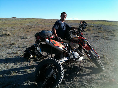
Of course Van was laughing and found complete enjoyment in my misery and frustration. After trying to work the jacket loose, we realized there was no way to get it out without removing the entire rear tire and pulling it loose from the rear sprocket. Here is a photo of Van holding the weight off the rear of my bike and the wheel with the destroyed motorcycle jacket. Definitely a task for 2 people.


As I angrily threw my tools back in my front tool bag, I of course forgot to secure Cody to the mini-bungie on the handlebars. I fired the bike and continued my cross country desert race to the "Green River CutOff Road". About 15 miles down the Green River cutoff, and a good 30 miles from the crash site, I had calmed down. I looked down and noticed that Cody was missing. It was then that I realized I had forgotten to strap him back down. This was a very dark and emotional moment of the trip for me. For anyone that has kids, you know how precious these little creatures are to them. I was already preparing myself for the wrath of Jonas when he was to find out that Cody had been left for dead in the desolate Green River desert.

We were making good time along this smooth and well graded dirt road across the desert into Castledale. The whole time I was scheming ways of recovering Cody Maverik in my head. I figured in a couple of days, I could get in my FJ Cruiser and use my GPS to go right back to the crash site and recover the dead penguin. I also came up with an idea to buy the exact Cody Maverik online and roll him in the dirt a few times so he looked beat up worn like the original. This was a very dark and desolate ride for me into Castledale.

We arrived at the hotel where the owner was awaiting our arrival. It turns out we were the only guests for the night. He gave us the keys, turned out the lights in the office and went home.

After climbing out of the shower, Van had carefully placed the beloved penguin on the bed. It turns out, that after he had fallen from my handlebars, Van noticed him and picked him up and stuffed him in his tank bag. Seeing Cody was like breathing fresh air and becoming whole again. I had to go out in the parking lot and give Allison a call and share the whole ordeal with her. She of course understands how much these little stuffed animals mean to our kiddoes. Here is a photo of Cody looking in the mirror at his gnarled hair after the crash.


Total miles today: 227
Total miles since home: 932

Alive in Park City

Just wanted to post and let everyone know I arrived home today at 3pm safe and sound. I'll post day 5 and 6 shortly.


Sunday, June 27, 2010

Utah Moto Day 4

Just pulled into Castledale on our way back north after a 225 mile day where I almost lost Cody. Details to follow on the day 5 post. We called the hotel from Green River tonight to let them know we were coming. Turns out we are the only ones staying in the entire hotel. The owner went home after we pulled in.

Day 4 started out of blanding heading northwest into the Abajo mountains. We climbed to about 10500 and were presented with breath taking views of the cedar Mesa looking south. I was familiar with the road as a friend from blanding took me up there once. We saw 2 black bear that time. These are some rugged mountains. Here is a photo of Van at the junction of the beef basin road.


The road from here quickly started descending into the southern part of the needles in canyonlands. I kept thinking how Allison would love the wildflowers up here. Truly amazing scenery. Here is a photo looking down into beef with the LaSals in the background.


There were cows every where. No big surprise considering beef basin is Blm land. We stopped at this old Anasazi tower which is literally right off the jeep trail. Beef basin is famous for it's plethora of ruins. Hopefully I can come back someday in the FJCruiser and see more.


We then arrived at the famous "bobbies hole" which has destroyed many jeeps. Once you go down this hill the only way out is to either come back up or go out elephant hill in canyonlands. In other words you are comittted at this point. Van took it first and lost control of his bike. He shattered his mirror in the process. Here he is descending with his 400lb bike. It gave me butterflies and caused me to curse a bit in my helmet. I read somewhere that a typical bill for the towtruck out of bobbies is about $2000 for a jeep Not sure for a bike and glad I didn't have to find out.


We then proceeded into the back entrance of the needles where we had to open a cattle gate. No fee station or ranger but no big surprise considering we were probably the only people to pass through that day. The needles was empty. We saw no one and to be honest it was almost eery. But considering the mighty jeep destroying elephant hill and bobbies hole are the only way in and out it was understandable. We proceeded down devils lane and stopped to try and find some petroglyphs a fellow jeeper shared with me. After some searching nothing turned up. Here is a photo of myself and the famous needle rocks in the background.


We then made our way over to the confluence of the green and Colorado rivers. The last time I was there was when I ran cataract canyon before I was married. Because of the intense heat I was wishing I was at river level. On our way over we encountered a man and woman hiking to the confluence. They said they were about 7 miles from their car and had no food. I gave a couple cliff bars and they both snarfed them down. Turns out the woman was 15 months pregnant. I would be surprised if they are still married after that hike. Here is a picture of Cody at the confluence. Notice the difference in water colors.


Only one more major Eco challenge adventure before departing canyonlands. We must exit by climbing the famous and mighty elephant hill. This thing has caused lots of damage to both jeeps and motorcycles. I only dropped my bike twice but luckily caused no damage to bike or bone. Here's a picture where we have carefully backed my bike down and I'm getting ready for run number 2.


After a few tries and some time we finally conquered and were on our way to Needles outpost for gas and water. Because it was 6:30 already we decided phone the wives using the satellite phone and let them know of our intentions to stay on route and head north into lockhart basin where we would camp. Turns out the outpost was closed so we couldn't buy fuel. No big deal considering I still had 1.5 liters in the rear and a good solid 2 in the front. We filled up the water and headed into the super desolate and seriously slow moving lockhart basin towards Moab. Here's a photo of van using the SAT phone at needles.


The first part of lockhart road was loaded with campers and hippies but no surprise considering highway 211 is right there. After riding a few miles it was obvious they didn't come down the basin from Moab. We rode late into the evening and watched the sunset as we slowly navigated. The lighting was seriously magical in this fabled valley. We passed where you could see the needles overlook above the valley floor and wondered if anyone was up there looking down at these 2 clowns on their dirt bikes riding into the sunset. We finally came to a section where the road started climbing and was getting very rough and decided to setup camp and call it a day. Here is a photo of camp just as the sun was coming up. This goes down as one of the most magical days of motorcycling for me. Camped in the middle of nowhere along a jeep road in the middle wild Utah. We wouldn't see another person until leaving the lockhart trail.


Total miles Today: 123
Total miles since home: 705

Alive in Moab

Just arrived Moab after camping in Lockhart basin for the night. Details to follow.


Just a quick photo of Cody on Hurrah Pass.

Friday, June 25, 2010

Utah Moto Day 3

Note to self: don't buy a motorcycle battery from Walmart. iPhone charging system is having problems due to the failed battery in my bike. So basically this means I'm not uploading gps coordinates as often. Not a huge deal considering were pretty much out of any coverage area most of the day. Just a side note, Van is carrying a sattellite phone in case of any unexpected emergency.

Day started with a ferry ride across Lake Powell to Halls Crossing. The Colorado river is definitely a geographical obstacle inside our state. No riding through the middle of it like muddy creek.


A few miles down the highway we stop at Castle Creek ruins which I've never seen despite the fact you can pull over in your air conditioned car and walk right up to them.


Now a good 60 miles of pavement to the Kane Gulch ranger station at the head of grand gulch where we are supposed to pickup a permit to visit the spectacular but hardly known "Moonhouse" ruins. But of course the ranger station is closed so we proceed anyway and pay our fee at the start of an old pioneer Mormon trail heading east into comb wash.


The moonhouse is considered the largest Anasazi ruin complex on the entire cedar Mesa. Consisting of approx 49 rooms in a quarter mile, this site housed many ancient people. The white paint and dots in the photo below is where it's name originates.


I'm sure the reason they aren't more popular is because of the location. The road itself would not be good for the mini van and the hike down to the canyon floor would not be suitable for the elementary field trip. Definitely an experience to check off my bucket list.

We then descended into comb wash which gets it's name from the huge comb ridge to the east. This entire ridge is loaded with Anasazi ruins which I've yet to see. Here's a photo of Van resting as we head north along comb wash.


We then crossed hwy 95 and rode our bikes up the posey trail to the top of butler wash where we ended our day hiking down to the tower house ruin. This was my 2nd time to tower house. I took Allison and the kids a couple weeks ago while the weather was still spring like. Here is a photo of tower house with a rare candelabra cactus which I've only seen here in Utah.


Tomorrow we head north through beef basin and enter the needles district of canyonlands national park on the south end. We hope to make Moab tomorrow night via the lockhart basin. Stay tuned.

Total Miles for the day: 139
Total Miles since home: 582