We still had a good 45 or so miles of brutal rocky jeep trail before reaching Moab. It was definitely slow going but as the trail twisted and turned with the contour of the geography, we would constantly go from sunshine to shade. Occasionally we would hit some climbs which would require me to stop and give it a good look before making the final path selection. Overall the ride was pleasant but slow going to the tune of 15 - 20 mph. This drive would take days in a jeep.
Eventually we came to a fairly steep descent down into the main plateau just before heading up to Hurrah Pass. All of the sudden we passed a group of people riding ATVs with no helmet of course headed out to Chicken Corners overlook on the Colorado. The no helmet thing is quite common with ATV riders.
Hurrah pass felt like a major milestone but we still had a good 15 to 20 miles into Moab. Once we reached Moab, it was time to head to the Pancake Haus which serves up some serious breakfast for the hungry "Moab-ite".
As we were getting seated, there was a guy standing there with his full moto gear and KTM riding jacket. Of course we looked at each other and realized we were from the same tribe and decided to all have breakfast together. Turns out this guy is riding his KTM across the "TAT" or Transamerican Trail which is a special route designed for street-legal dirtbikes. The full ride distance is 4800 miles coast to coast and he was about 2500 miles into it at Moab.
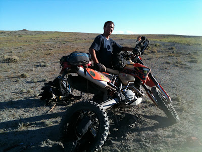
After breakfast, we of course had to go outside and check out his bike fully loaded with every gadget imaginable. He is riding the KTM adventure 640 which is a much heavier bike. His chance of riding that thing up Elephant hill would have been slim to nothing. It would have required a helicopter airlift to get that thing out of the Needles.

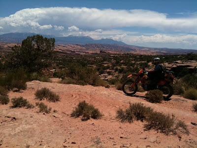
We gassed the bikes up at the local Maverik and poured a gallon of ice cold water over our heads and started out towards the Gemini Bridges trailhead to start making our way north-west towards Green River. Here is a picture looking back towards Moab over Poison Spider Mesa and the La Sal Mountain range. The scenery in this part of Utah never disappoints.

We hit pavement on the Canyonlands Dead Horse state park highway and then started west on another dirt road. The original route I had planned was supposed to take us over the Crystal Geyser jeep trail but for some reason took us to a dead end where an old oil pump was slowly sucking crude out of the earth. We back tracked a bit and found a road heading due west. I thought for sure this would take us to Green River. Turns out the road we were on was the "Secret Spire" trail which ultimately took us to the canyon bottom and along the banks of the Green River. The topo map I was carrying in my pack showed the road going north for a while and then a little squigly line exiting out the canyon to the top. We rode for about 5 miles and then decided there was no way we were going to get our bikes out via a little black squigly line on the map. So we turned around and eventually made our way to Green River. This is a photo of the switchback loaded road going under the "Secret Spire" into the canyon bottom.

Our little detour to the "Secret Spire" cost us a lot of time and it was getting late. So after arriving Green River, we decided to call the hotel in Castledale and reserve a room. After all we didn't want to arrive and find a completely booked hotel and have to sleep in the local park. So we gassed the bikes, snarfed down a delicious Arby's dinner and hit the road.
When I planned the route out of Green River to Castledale, I didn't want to ride on Highway 6 at all. So I found an old road on the GPS software which I assumed was the old highway before they built US Highway 6. It looked very legitimate and ran directly parallel to US 6. So that is the one I loaded in the GPS. After riding north on this old road, it basically vanished and turned into nothing but barren grey Green River desert. I was determined to get to the "Green River Cuttoff" road to Castledale so we decided to start riding cross country.
We had to constantly cross over natural ditches and minor crevasses in the earth but they didn't really bother us. As I was riding along, all of the sudden my rear tire froze and started skidding. It brought me to a complete dead stop. This was extremely odd and I thought for sure my bike was having some sort of major mechanical failure. As I looked at the tire to assess the situation, I noticed my riding jacket had vibrated loose from the bungie cords and had become sucked into the chain and sprocket at least 1 full revolution. This was not good considering we were losing daylight and still had a long way to go.
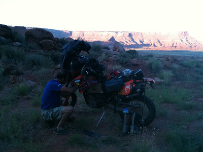
Of course Van was laughing and found complete enjoyment in my misery and frustration. After trying to work the jacket loose, we realized there was no way to get it out without removing the entire rear tire and pulling it loose from the rear sprocket. Here is a photo of Van holding the weight off the rear of my bike and the wheel with the destroyed motorcycle jacket. Definitely a task for 2 people.

As I angrily threw my tools back in my front tool bag, I of course forgot to secure Cody to the mini-bungie on the handlebars. I fired the bike and continued my cross country desert race to the "Green River CutOff Road". About 15 miles down the Green River cutoff, and a good 30 miles from the crash site, I had calmed down. I looked down and noticed that Cody was missing. It was then that I realized I had forgotten to strap him back down. This was a very dark and emotional moment of the trip for me. For anyone that has kids, you know how precious these little creatures are to them. I was already preparing myself for the wrath of Jonas when he was to find out that Cody had been left for dead in the desolate Green River desert.
We were making good time along this smooth and well graded dirt road across the desert into Castledale. The whole time I was scheming ways of recovering Cody Maverik in my head. I figured in a couple of days, I could get in my FJ Cruiser and use my GPS to go right back to the crash site and recover the dead penguin. I also came up with an idea to buy the exact Cody Maverik online and roll him in the dirt a few times so he looked beat up worn like the original. This was a very dark and desolate ride for me into Castledale.
We arrived at the hotel where the owner was awaiting our arrival. It turns out we were the only guests for the night. He gave us the keys, turned out the lights in the office and went home.
After climbing out of the shower, Van had carefully placed the beloved penguin on the bed. It turns out, that after he had fallen from my handlebars, Van noticed him and picked him up and stuffed him in his tank bag. Seeing Cody was like breathing fresh air and becoming whole again. I had to go out in the parking lot and give Allison a call and share the whole ordeal with her. She of course understands how much these little stuffed animals mean to our kiddoes. Here is a photo of Cody looking in the mirror at his gnarled hair after the crash.

Total miles today: 227
Total miles since home: 932

1 comment:
I was really sad reading about Cody. I'm so glad the story ended happy and you are safe and well.
Post a Comment